Canterbury
Canterbury brings together the Southern Alps, fertile plains, the volcanic Banks Peninsula and Christchurch, the regional capital experiencing renaissance after the 2010-2011 earthquakes.
Canterbury is the major region of the central-east South Island, backed by the Southern Alps to the west and opening onto the Pacific Ocean to the east. Christchurch is its capital and principal gateway. The region combines some of New Zealand's most fertile agricultural plains, snow-capped peaks, the volcanic Banks Peninsula and an urban culture in full reconstruction following the 2010-2011 earthquakes.
Practical Information at a Glance
- Access: Christchurch International Airport (CHC), the South Island's primary hub.
- Internal Transport: Car rental recommended for exploring the region; intercity buses to Akaroa, Kaikōura and ski fields.
- Suggested Duration: 3 to 5 days to cover Christchurch, Banks Peninsula and the alpine foothills.
- Best Time to Visit: December to February for hiking and beaches; June to August for skiing at Mount Hutt and surrounding fields.
What to See
The region offers a rare diversity of landscapes. The Canterbury Plains stretch endlessly, crisscrossed by irrigation channels and livestock farms. To the west, the Southern Alps culminate with Aoraki/Mount Cook (3,724 m), visible from the plain in clear weather. Banks Peninsula, a collapsed ancient volcano, shelters the bays of Akaroa and Lyttelton, with deep waters and verdant hills.
History and Context
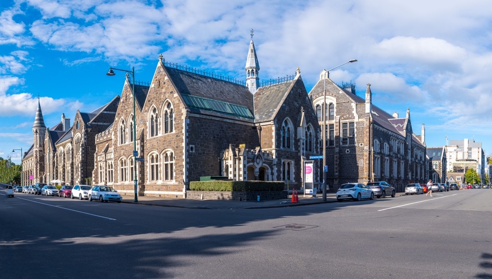
The Māori (iwi Ngāi Tahu) have occupied the region for centuries, exploiting coastal resources and alpine passes. The first British settlers arrived in 1850 under the auspices of the Canterbury Association, founding Christchurch on a planned Anglican model. The city retains neo-Gothic architecture inherited from this period, partly destroyed by the 2010 and 2011 earthquakes (magnitudes 7.1 and 6.3), which killed 185 people and permanently reconfigured the city centre.
Highlights of Your Visit
Christchurch in Reconstruction
The post-earthquake city centre has become a laboratory for contemporary architecture. The Cardboard Cathedral (provisional cardboard and steel cathedral) symbolises local resilience. The Ōtākaro Avon River Corridor transforms the Avon riverbanks into a linear park. Riverside Market and the new city's laneways concentrate restaurants, galleries and independent boutiques.
Banks Peninsula and Akaroa
Akaroa is New Zealand's only village with French heritage, founded by Norman settlers in 1840. The bay is home to a colony of Hector's dolphins, an endemic species among the world's smallest cetaceans. Boat excursions allow for close observation.
Kaikōura and the Northern Coast
Approximately two hours north of Christchurch, Kaikōura is renowned for sperm whale watching, dusky dolphin sightings and sea lion colonies. The coastal road hugs spectacular cliffs between sea and mountain.
Ski Fields and Alpine Hiking
Mount Hutt, about 90 minutes from Christchurch, is one of the South Island's most accessible ski fields. In summer, the Rangitata and Rakaia valleys offer hiking routes and rafting through deep gorges.
Photography Tips
The raking morning light on the Canterbury Plains, with snow-capped Alps in the background, yields the best compositions from secondary roads west of Christchurch. At Akaroa, photograph the harbour early in the morning before tour buses arrive. For Hector's dolphins, favour a lens ≥ 200 mm from the boat.
Location and Access
Canterbury occupies the central-east South Island. Christchurch is connected to Wellington by frequent flights (approximately 1 hour) and to the rest of the South Island by State Highway 1 heading south (Dunedin, ~5 hours) and north (Kaikōura, ~2 hours). The TranzAlpine, a scenic train, links Christchurch to Greymouth while crossing the Southern Alps — one of the country's most renowned railway journeys.
Christchurch's city centre is walkable and served by a historic tram system. For Banks Peninsula and rural areas, a car remains essential. Disabled accessibility is good in the rebuilt city centre; variable in rural zones.
Nearby Attractions
- Akaroa — French-New Zealand village on Banks Peninsula, base for observing Hector's dolphins.
- Kaikōura — rugged coast to the north, New Zealand's whale-watching capital.
- Aoraki / Mount Cook — the country's highest peak, accessible from Canterbury via State Highway 80.
- Lake Tekapo — turquoise lake in the Mackenzie Basin, renowned for its starry skies (dark sky reserve).
- Christchurch — regional capital, cultural hub and starting point for all Canterbury itineraries.
Frequently asked questions
The Southern summer (December-February) suits hiking, beaches and water activities. Winter (June-August) is ideal for skiing at Mount Hutt. Spring (September-November) brings lupins in bloom across the Mackenzie Basin.
Yes, a car is strongly recommended once you venture beyond Christchurch. Public transport covers a few main routes, but Banks Peninsula, river gorges and ski fields are not conveniently served without a vehicle.
Hector's dolphins inhabit Akaroa Bay. Boat excursions departing from Akaroa allow for close encounter; shoreside observations are possible but less guaranteed.
This train traverses the Southern Alps between Christchurch and Greymouth in a single day. The route is renowned for views of the Otira Gorge and plains. It operates year-round; advance booking advised during peak season.
Reconstruction is well advanced but ongoing. The city centre presents a mix of contemporary architecture, restored heritage buildings and some remaining vacant sites. The original Anglican cathedral is undergoing lengthy restoration work.
Yes. The route via the Mackenzie Basin (Lake Tekapo, Aoraki/Mount Cook) connects Christchurch to Queenstown in a day's drive, with very worthwhile stops. Allow a minimum of two days for this journey if you wish to pause along the way.