Mount Aspiring National Park
Mount Aspiring National Park
3,550 km² of glacial valleys, the Tititea summit (3,033 m) and the Routeburn Track: complete guide to Mount Aspiring National Park from Wanaka.
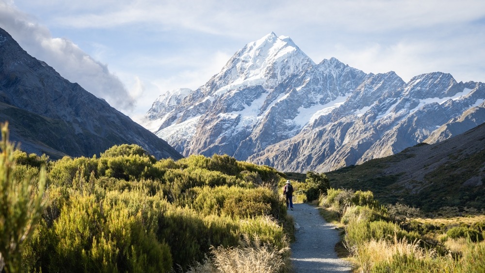
Mount Aspiring National Park spans more than 3,550 km² across the Southern Alps of New Zealand, making it the country's 3rd largest national park. Its iconic summit, Mount Aspiring (3,033 m), known as Tititea in Māori, towers over a territory of glacial valleys, beech forests and alpine trails shared with its neighbour the Fiordland National Park. The town of Wanaka is the park's main gateway.
Why visit Mount Aspiring National Park
The park is part of the UNESCO World Heritage site Te Wahipounamu, which encompasses the South Island's best-preserved alpine landscapes. It combines major hiking routes—including the Routeburn Track, one of New Zealand's Great Walks—accessible glaciers on foot, rivers suited to jet boating, and endemic wildlife rarely seen elsewhere (kea, Haast brown kiwi, blue duck).
Its pyramidal silhouette earned Mount Aspiring the nickname "Matterhorn of the South". The summit has attracted mountaineers since its first ascent in 1909, but most visitors come for half-day to multi-day hikes accessible to experienced walkers without technical gear.
History of the park
Long before European arrival, the Waitaha, Kati Mamoe and Ngai Tahu peoples frequented these valleys for hunting, fishing and especially searching for pounamu, the greenstone used to craft tools and ornaments. Several current trails—notably the Greenstone and Caples tracks—follow ancient Māori pathways, and local place names retain many te reo Māori designations.
In the 19th century, European explorers traversed the region during the gold rush. Little precious metal was extracted, but surveyor Charlie Douglas conducted precise topographic surveys that remain authoritative today. Tourism emerged by century's end in the Routeburn valley.
The park was officially established in 1964, becoming New Zealand's 10th national park and extending continuously with Fiordland to form a vast protected area managed by the Department of Conservation (DoC).
What to see and do in the park
Major hiking routes
- Routeburn Track — approximately 33 km over 2 to 3 days, one of the Great Walks. The trail crosses alpine passes and valleys, connecting the park to Fiordland.
- Rees-Dart Track — 4 to 5-day loop along the Rees and Dart rivers, reserved for experienced hikers.
- Cascade Saddle — technical alpine crossing offering views of Dart Glacier and the Matukituki valley.
- Greenstone and Caples — four days on ancient Māori trails through forests and grasslands.
Day walks
- Rob Roy Glacier — 3 to 4 hours return from Raspberry Flat carpark, featuring views of a hanging glacier and its waterfalls.
- Aspiring Hut — gentle trail through the Matukituki valley, family-friendly.
- Blue Pools — short walk to intensely blue pools of water.
- Brewster Hut, Lake Sylvan, Haast Pass Summit Track — other options lasting a few hours to a full day.
Mountaineering and other activities
Ascending Mount Aspiring, Mount Pollux, Mount Brewster or Mount Awful requires advanced technical skills (ice, rock) and good acclimatization. Expect generally 2 to 4 days for Mount Aspiring depending on the route.
The park also offers light aircraft or helicopter scenic flights from Wanaka, jet boat excursions on the Dart, Wilkin, Matukituki or Makarora rivers, and canyoning descents through tributary gorges.
Wildlife and flora
Vegetation ranges from beech forests (red, silver and mountain beech) with over 70 fern species to alpine meadows carpeted with buttercups and daisies. Wildlife highlights include several iconic birds:
- The kea, an inquisitive and vocal alpine parrot
- The mohua (yellow-crowned kaka)
- The Haast brown kiwi, with a sanctuary area within the park
- The blue duck (whio), found exclusively in torrential streams
- The rock wren
At night, pekapeka bats and morepork owls emerge. Introduced species—deer, chamois, possums, rats—constantly pressure these ecosystems, and the DoC conducts ongoing control programmes.
Practical advice
Southern Alps weather changes rapidly, even in summer. Before each walk, register your itinerary with the Department of Conservation, check trail bulletins and bring clothing for all conditions, a topographic map and emergency provisions.
Great Walks (Routeburn) require hut reservations in peak season, to be booked several months in advance through the DoC. On multi-day routes, stream water is generally drinkable after filtering.
Best time to visit
The optimal hiking season runs November through March, when snow has melted from passes and huts are staffed. December to February sees peak visitor numbers. In autumn (April), beech trees display golden hues but early snow at altitude is possible. Winter (June to September) is reserved for equipped alpinists and heli-ski enthusiasts.
How to get there
The main entry point is Wanaka, accessible by car from Queenstown (approximately 1 hour) or Christchurch. From Wanaka, a road leads to Raspberry Flat in the Matukituki valley (the starting point for Rob Roy and Aspiring Hut). Glenorchy, at the northern end of Lake Wakatipu, provides access to the Routeburn, Rees-Dart, Greenstone and Caples trails. To the north, Makarora and State Highway 6 cross Haast Pass and provide access to the park's northwestern section.
Nearby
- Fiordland National Park — immediate neighbour to the south, featuring Milford and Doubtful Sound.
- Arthur's Pass National Park — another major alpine crossing, further north in the Southern Alps.
- Cape Foulwind — on the west coast, a possible stop when heading north from Haast Pass.
- Cathedral Cove and the Banks Peninsula complete a nationwide itinerary.
FAQ
Frequently asked questions
The ascent typically takes 2 to 4 days return depending on the route (most commonly via Bonar Glacier), snow conditions and team experience.
Yes. It is a demanding mountaineering climb combining ice, rock and exposed ridges. Good physical fitness, confirmed high-altitude mountaineering experience and, for most visitors, guidance from a local guide are essential.
Park access is free. However, hut and camping nights on the Routeburn Track and certain other trails require reservation with the Department of Conservation, to be arranged several months ahead for the summer season.
Yes. The hike to Rob Roy Glacier (3 to 4 hours) or the walk to Aspiring Hut from Raspberry Flat are doable day trips from Wanaka, accounting for approximately 1 hour driving to reach the trailheads.
Plan your trip
Mount Aspiring National Park fits naturally into a South Island circuit, between Wanaka, Glenorchy and the west coast. To build a custom itinerary combining hiking and cultural stops, explore our New Zealand travel suggestions.
Interested in this visit?
We can include it in your personalised itinerary.