Mount Victoria in Auckland
Mount Victoria in Auckland
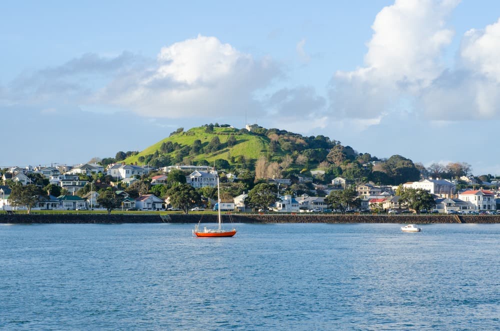
A volcanic cone in Devonport, former Maori pā and military stronghold, Mount Victoria (Takarunga) offers a 360° view over Auckland and the Hauraki Gulf.
Mount Victoria, or Takarunga in the Maori language, is a volcanic cone in Devonport, on Auckland's North Shore. A sacred site for Maori, a former maritime signalling station, then a military fort, it now offers a sweeping panorama over Waitemata Harbour and the Hauraki Gulf. Access is free, open to the public, and reachable in less than an hour from the city centre.
Why visit Mount Victoria
Few sites concentrate so many historical layers across 87 metres of elevation gain. Takarunga overlays an 18th-century Maori pā, a Victorian signal station, a late 19th-century armed fort, bunkers from both world wars, and an active water reservoir. The summit is reached on foot in 10 to 20 minutes from Devonport ferry terminal, making it one of Auckland's most accessible viewpoints.
The appeal is threefold: a 360° panorama over the city and its volcanic islands, a tangible reading of New Zealand history (Maori presence, colonisation, militarisation, restitution), and the charming Devonport neighbourhood for extending your visit.
The History of Takarunga
A volcanic cone formed 20,000 years ago
Mount Victoria is a scoria cone formed approximately 20,000 years ago during a single eruption. It belongs to the Auckland volcanic field, which contains over 50 extinct cones scattered across the region. Volcanologists consider the field dormant rather than permanently extinct.
Its Maori name, Takarunga, means "the hill that rises above", in contrast to Takararo ("the hill below"), now flattened and transformed into Cambria Reserve nearby.
A Maori pā on the heights
Long before European arrival, Takarunga was a pā—a fortified village—occupied by the iwi of Tāmaki Makaurau. The chief Kiwi Tāmaki resided there in the 18th century. Traces remain on the hillside of kūmara (sweet potato) storage pits and agricultural terraces cut into the slope.
Flagstaff Hill and militarisation
In 1841, a maritime signalling station was installed at the summit to inform Auckland Harbour of incoming vessels. The site then took the name Flagstaff Hill. Declared a public reserve from 1880 onwards, the hill was militarised a few years later: an armed fort was built in 1885, amid fears of Russian invasion.
During both world wars, Mount Victoria served as a coastal defence post. Concrete bunkers, tunnels and observation posts remain. Among notable features is a restored disappearing gun, one of the last examples of its kind in the world. One of the bunkers now houses the Devonport Folk Club.
Maori restitution and shared management
Takarunga is recognised as a tūpuna maunga (ancestral mountain). It is one of 14 sacred volcanoes in Auckland transferred in 2014 to the collective Ngā Mana Whenua o Tāmaki Makaurau, as part of a settlement linked to the Treaty of Waitangi. Management of the site is now shared between the Tūpuna Maunga Authority and Auckland Council.
What to see on site
The panorama from the summit
The view encompasses Waitemata Harbour, Auckland city centre dominated by the Sky Tower, the volcanic island of Rangitoto, Devonport's beaches and the Hauraki Gulf. On clear days, the gaze reaches Mount Eden, the Coromandel Peninsula and Waiheke Island.
Military and industrial remains
- Bunkers and defence tunnels from both world wars
- Restored disappearing gun
- Water reservoir carved from the original crater, still in service
- Mushroom-shaped, coloured air vents at the summit, marking the pumping station installed in 1894
The Signalman's House
This Victorian villa housed the signalling agents, who informed residents of incoming ships using flags. The last signaller left the house in 1943. The building now houses the Michael King Writers Centre, a literary hub supported by Creative New Zealand and the University of Auckland, which hosts writers' residencies and public events.
Practical Information
- Free access, open year-round
- Open-air site, little shade at the summit
- Proper walking shoes recommended (short but steep slope)
- Allow 1 to 2 hours on site to enjoy the panorama and explore the remains
- Site shared with a primary school, historic cemetery, tennis court and viewpoint: respect for residential areas requested
When to visit
Mount Victoria can be visited year-round, but the southern summer (December to March) offers the most stable conditions and best visibility over the gulf islands. Autumn (April-May) remains pleasant, with fewer visitors. In winter, frequent showers can significantly reduce the panorama: prefer late morning after clouds have passed.
For photography, late afternoon highlights Auckland's skyline on the western side. Sunset is one of the site's busiest times.
How to get there
The simplest access from Auckland city centre is the Devonport ferry, which crosses Waitemata Harbour in about ten minutes. From the terminal, follow Victoria Road, the neighbourhood's main street, then turn right onto Kerr Street. The main trailhead to the summit is on the left side of the street. The climb takes 10 to 20 minutes on foot.
The summit is also accessible by car via a narrow road, with a small car park of limited spaces. Cycling and tourist minibus are other options.
In the Surroundings
Devonport is a historic neighbourhood of Victorian villas, with cafés, independent bookshops and galleries. North Head (Maungauika), another militarised volcanic cone, lies a 20-minute walk away and offers better-preserved fortifications. Cheltenham and Narrow Neck beaches are accessible on foot.
To extend your New Zealand journey, other sites are worth visiting:
- Cathedral Cove on the Coromandel Peninsula, visible from the summit
- The Museum of New Zealand Te Papa Tongarewa in Wellington to deepen your understanding of Maori history
- Banks Peninsula on the South Island
FAQ
Frequently asked questions
Mount Victoria, or Takarunga, is located in the Devonport neighbourhood on Auckland's North Shore, a few minutes' walk from the ferry terminal.
No. Entry and access to the summit are completely free, whether on foot or by car.
The cone itself experienced only a single eruption approximately 20,000 years ago. However, it is part of the Auckland volcanic field, which volcanologists consider dormant rather than permanently extinct.
Takarunga means "the hill that rises above" in Maori, in contrast to Takararo ("the hill below"), located nearby and now flattened.
Military bunkers and tunnels, a restored disappearing gun, Maori terraces and storage pits, as well as the coloured air vents of the underground water reservoir installed in 1894.
Planning your trip
Mount Victoria fits easily into a stay in Auckland, at the beginning or end of a circuit through New Zealand. To build a complete itinerary combining Maori culture, volcanic landscapes and coastal cities, consult our New Zealand travel packages.
Interested in this visit?
We can include it in your personalised itinerary.