Amon Sûl
Amon Sûl
Amon Sûl, also known as Weathertop, a limestone hill in the Waikato region used as a set by Peter Jackson. Tolkien history, access and viewing from Waikaretu Road.
Amon Sûl, better known as Weathertop, is one of the locations from The Lord of the Rings with a tangible presence in New Zealand. The hill sits in the Waikato region on the North Island, near Port Waikato, roughly 80 to 100 km south of Auckland by road. The site layers two realities: a distinctive limestone formation, and the memory of a pivotal scene from Peter Jackson's trilogy filmed on this very terrain.
Why this hill captures attention
Weathertop is not a theme park or a manicured attraction. It is a mound set amid working farmland, lost in a landscape of grassland, limestone cliffs and rocky outcrops. The circular ruins visible in the film do not exist on the ground—they were added digitally in post-production. What remains is the natural backdrop itself: the landform, the light, the silence—everything that framed the shoot.
The site's appeal works on two levels. For Tolkien readers and trilogy fans, it is an identifiable landmark of Middle-earth. For geology enthusiasts, it is a limestone outcrop with fossilized formations and a natural cavity at the summit whose ceiling bears patterns resembling coral structures, carved by erosion over millennia.
History in Tolkien's mythology
In J.R.R. Tolkien's world, Amon Sûl means "hill of wind" in Sindarin. It is the highest and most southerly of the Weather Hills, in Eriador, east of Bree.
A watchtower was built there by Elendil near the end of the Second Age to guard the Northern realm (Arnor) and keep watch over the Great Eastern Road. It housed one of the palantíri, those far-seeing stones used for distant communication. When King Eärendur died in 861 of the Third Age, Arnor fractured into three kingdoms: Arthedain, Cardolan and Rhudaur. The hill, lying at their confluence, became a recurring point of contention.
In 1409 of the Third Age, forces of the Witch-king of Angmar set Weathertop aflame. Arveleg I and the last prince of Cardolan fell in battle. The palantír was moved to safety at Fornost Erain. The tower itself was never rebuilt. By Frodo's time, only a worn circle of stones remained at the flattened summit.
The Lord of the Rings scene
In The Fellowship of the Ring (2001), Weathertop is a turning point in the narrative. On 3 October 3018 of the Third Age, Frodo, Sam, Merry and Pippin, accompanied by Aragorn, make camp at the foot of the hill. Aragorn ventures ahead as scout. The Nazgûl attack at nightfall. In a hollow below the mound, the Witch-king of Angmar stabs Frodo with a Morgul blade—a wound that will define the entire first arc of the quest.
Gandalf is not present during this assault; he had passed through Weathertop alone days earlier and confronted the Nazgûl himself. This detail matters for readers revisiting the book after the film.
In the Hobbit trilogy, Weathertop appears briefly as a meeting place for Azog, Yazneg and Fimbul—an addition by the screenwriters, absent from the novels.
What you see on location
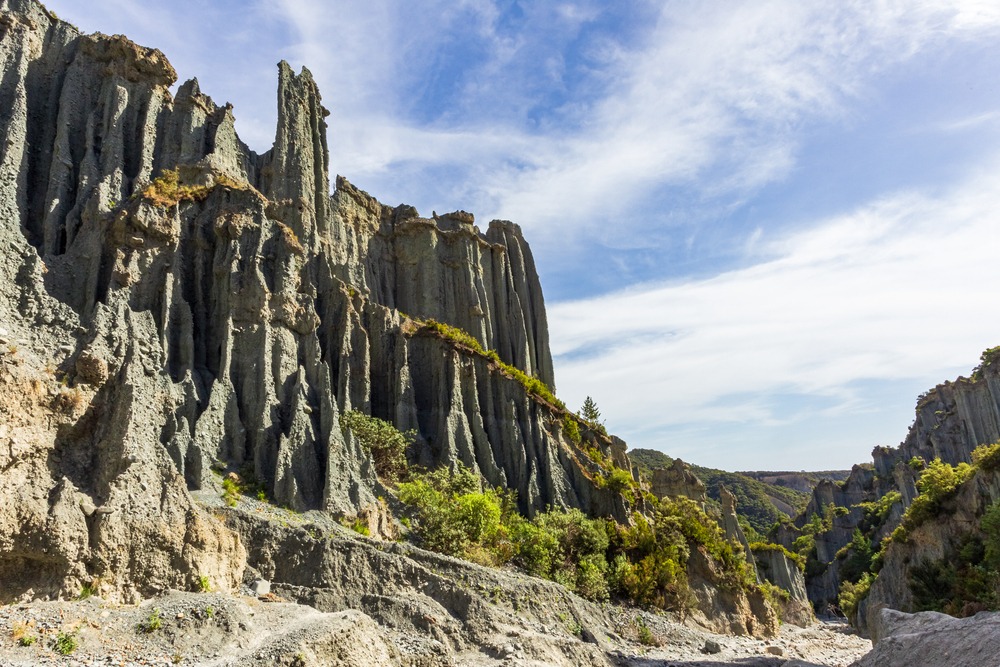
From Waikaretu Road, the hill's silhouette is unmistakable: a flattened summit, pale limestone faces, farmland rolling in every direction. The landform is not dramatic, yet it stands out clearly from the agricultural terrain.
- The summit: flattened, with a natural cavity whose ceiling bears patterns reminiscent of coral structures, remnants of limestone erosion.
- The flanks: limestone cliffs, rocky outcrops, fossilized formations attesting to a marine past.
- The panorama: grassland, rounded hills, a changing sky—a landscape echoing Jackson's vision of Middle-earth, wholly unadorned by tourism infrastructure.
Practical tips
The hill lies on active farmland in private ownership. Access to the summit is not permitted without the landowner's prior consent, and permissions are seldom granted. Visits are, in most cases, restricted to viewing from the road.
- Respect private property absolutely: no trespassing, no parking on farm entrances.
- Plan a half-day round trip from Auckland on a dry day for unimpeded viewing.
- Bring water and provisions: no tourist facilities exist on or near the site.
- Photograph from roadsides without obstructing rural traffic.
How to get there
The simplest viewing point lies along Waikaretu Road, accessible by vehicle from Port Waikato. From Auckland, allow one to two hours' drive depending on your route (via State Highway 1, then secondary roads toward Port Waikato and Waikaretu).
Most roads leading to the area are gravel rather than sealed. They become treacherous in wet weather. Signage is virtually non-existent: download offline maps or load your GPS beforehand, and do not hesitate to ask locals for the best vantage points.
Nearby attractions to combine
Weathertop pairs well with a thematic "Middle-earth" loop or a broader exploration of New Zealand's geology:
- The Ford of Bruinen, another Lord of the Rings filming location.
- Kura Tawhiti (Castle Hill), rock formations used in The Chronicles of Narnia.
- The Elephant Rocks, limestone boulders that echo Amon Sûl's landscape.
- The Moeraki boulders, to deepen your geological understanding of the country.
Frequently asked questions
Frequently asked questions
Not freely. The site sits on private farmland and requires the owner's permission. Authorizations are rare, and visits in practice amount to viewing from Waikaretu Road.
No. The circular ruins seen in The Fellowship of the Ring were added digitally. All that remains is the natural limestone landform used as backdrop.
Plan for one to two hours' drive each way depending on your route and conditions, plus time spent viewing. A half-day excursion is reasonable.
Southern summer (December–March) offers the best road conditions and light. In winter, gravel roads become slippery after rain.
No, signage is almost non-existent. Plan your route in advance using offline maps and identify vantage points before departing.
Planning the rest of your journey
Weathertop is just one stop among countless filming locations and remarkable landscapes across the country. To craft an itinerary that blends Tolkien landmarks, geology and wilderness, explore our New Zealand tours.
Interested in this visit?
We can include it in your personalised itinerary.